
Walk a Sarasota Street Search
Begin with one complete Sarasota address, even when the goal is a whole block. The Bill Furst, Sarasota County Property Appraiser connects the street number to a parcel, owner, situs address, mailing address, legal description, sales, exemptions, and a map link. A situs address is where the land sits. A tax mailing address is where the county sends notices, so it may belong to an owner who lives elsewhere.
Once one parcel is sound, move outward. This street-by-street method keeps people and lots from being mixed up when similar street names, units, condos, or directional labels appear.
- Search the address in the Property Appraiser real-property search, then save the parcel number, situs, owner, and legal description.
- Open Map Property Search and click the target lot plus nearby parcels. Compare every popup with its parcel card.
- Use the current owner in the Clerk Official Records index. Find the purchase deed and confirm the same legal description.
- Search city permits by bare street name, number, owner, parcel, or postal code. Ask Development Services for an older permit jacket when needed.
- For registered voters by street, request a lawful public extract from Sarasota County Elections. For older occupants, consult reverse directories at the History Center.
Sarasota Street Directory Fields
The Property Appraiser offers Real Property, Advanced, Tangible, and Map Property Search modes. Its address and subdivision controls make it the main current street directory tool. Use fewer fields first. Trust names, suffixes, and postal-city differences can make a narrow query miss a valid parcel.
| Search field | Input | Useful street task | Local caution |
|---|---|---|---|
| Owner Name | Text | Find parcels tied to a person or trust | Try spelling variants |
| Street Number | Text | Pinpoint one situs | Units may be separate |
| Street Name | Text or autocomplete | Browse parcels by street | Avoid too many suffixes |
| City / ZIP | Text or selector | Narrow a mailing area | Postal Sarasota may cross jurisdictions |
| Parcel / Account | Text | Return to an exact lot | Best bridge between systems |
| Subdivision / Condo | Text or selector | Group a development | Not a resident roster |
| Map Search | Map or address | Click adjoining lots | Layers describe land, not people |
A parcel result can show assessed and taxable value, improvements, qualified and unqualified sales, and homestead status. Homestead supports owner occupancy, but it does not identify every person at the address. The street directory remains a chain of records, not one complete household list.
Sarasota Records Organized by Address
Each Sarasota custodian answers a different question. The parcel number and legal description are the strongest join keys. A modern street address can change, while the recorded lot, block, plat, or metes-and-bounds description preserves the land identity.
| Sarasota source | Keeper | Evidence by street | Access route |
|---|---|---|---|
| Assessment roll | Property Appraiser | Owner, situs, mailing, parcel, sales, exemptions | Web search, map, downloads, request |
| Parcel GIS | Property Appraiser / county | Lot shapes, adjacent parcels, mapped districts | Free map and open data |
| Official Records | Sarasota County Clerk | Deeds, mortgages, liens, judgments, plats | Web index from 1990; Public Access earlier |
| Voter file | Supervisor of Elections | Nonexempt voters by residence | Records request; protected fields removed |
| Permits | City Development Services | Owner, contractor, project, parcel, job address | Portal and archived jacket request |
| Reverse directory | County History Center | Listed occupant or business by address | Offsite Hill-Donnelly request |
The city, county, and postal label do not always match. A Sarasota mailing address can lie outside the incorporated city, and 34243 can reach Manatee County. Verify jurisdiction from the parcel before choosing the court, deed, election, or permit custodian.
Map Sarasota Parcels by Street
The Property Appraiser Map Property Search turns a text result into a visual block. Search an address, zoom until parcel outlines show, click the target polygon, and open its property link. Then click each adjoining polygon in order. Sarasota County Open Data adds searchable GIS layers, downloads, legends, measuring tools, and map apps, although controls vary by application.
Parcel geometry prevents a common error: assigning one owner to an apartment building, condo unit, duplex, or adjacent vacant lot without checking the actual account. Zoning, flood, neighborhood, and district layers explain the place. They do not identify residents. A dependable Sarasota by-street review keeps a short log with house number, parcel ID, owner name as printed, and source date.
- Parcel
- A unit of land recorded and assessed under one account.
- Situs address
- The physical location of the parcel, distinct from the tax mailing address.
- Plat
- A recorded map that divides land into lots, blocks, streets, and easements.
- Criss-cross directory
- A directory arranged by street and house number instead of by surname.
Sarasota Streets Through Deed Records
The Clerk index is name-led, not a reliable modern-address search. Convert the Sarasota situs into a parcel and legal description first. Search the owner as a grantee, which means buyer, and limit the document type to deed. The result may list party role, instrument number, recording date, book and page, legal description, page count, and an eligible image.
The permanent online index begins January 1, 1990. Sarasota County Official Records exist from 1921 onward through electronic files or microfilm at Public Access. Take the last online book and page to the Clerk when the chain crosses that web cutoff. For land before July 1, 1921, check predecessor records in Manatee County. A deed proves a transfer of title, not that a buyer moved into the property. Mortgages and releases support the chain but do not transfer ownership.
Useful safeguard. Sarasota's free Property Fraud Alert sends notice when a registered name appears in a new recording, but it cannot stop a filing.
Sarasota Permits Along a Street
City permits add dates, work descriptions, owner names, contractors or agents, parcel IDs, and job sites to the street directory. The form separates Street Number from Street Name. Its instruction says to omit the directional prefix, suffix, and street type from the street-name field. That small detail matters when a search for a full label returns nothing.
The City of Sarasota permit search also accepts permit type, status, date window, application or permit number, business, owner, contractor, city, parcel ID, and postal code.
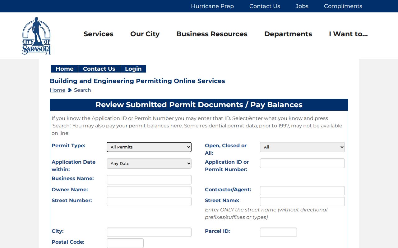
The portal warns that some residential permit data before 1997 may be absent. That is an access gap, not proof that no work occurred. Request the archived permit jacket from Development Services. Development Applications can also supply annexation, street vacation, street-name-change, variance, and site-plan files when an old address no longer matches the map.
Sarasota Voters by Street Request
My Voter Record uses a name and date of birth to authenticate one voter's own record. It is not a browse-by-street service. A street-level voter task instead goes to the Sarasota County Supervisor of Elections as a public-record request. Requests can be made online, by mail, email, fax, phone, or in person. A special service charge may apply when staff work exceeds 30 minutes.
Florida law makes many voter-registration fields public, including name and residence address, but protects Social Security numbers, driver-license or state-ID numbers, application source, and signature copies. Address Confidentiality Program participants and other qualified protected voters may not appear in the expected way. A voter extract identifies registered voters only. It omits people who are not registered and cannot establish a full household.
Older Sarasota Street Directory Clues
For past occupants, the Sarasota County History Center keeps ordinary city directories onsite. Hill-Donnelly reverse directories and telephone books are stored offsite, so request them at least three business days before an Osprey visit. A reverse volume is the most direct old by-address tool: find the street, move to the house number, then read the listed occupant or business. Exact Hill-Donnelly years were not published online and must be confirmed with staff.
The full directory shelves and entry abbreviations belong to the Sarasota directory book resource. For street work, note only what the edition prints and its publication year. Seasonal residents, renters, non-subscribers, and people omitted by older publishers may be absent. Sarasota's 1923 map, 1950 street map, plats, and aerials help match a changed label to the same parcel.
Resolve Sarasota Address Changes
Do not assume Sarasota had one documented citywide renumbering event. The official research did not establish such a year. Compare the legal description across dated maps and plats instead. Search variants such as a bare street name, an abbreviated suffix, a directional form, and the postal city. Development Applications handles street-name changes and annexations, so its application, staff report, ordinance or resolution, and map can explain an administrative change.
The 1921 creation of Sarasota County is a deeper boundary break. The first county court operated in the Hover Arcade while the permanent courthouse was built and opened in 1927. A street directory trail that reaches before July 1921 may shift to Manatee custodians even if the site is now firmly within Sarasota County. Publisher boundaries also lagged government borders, so some 1920s directories still grouped Sarasota with Bradenton or Manatee.
Limits of Sarasota Street Records
No official Sarasota street directory names every person in every home. Parcel rolls omit renters and household members. A mailing address may belong to an owner, trust, or manager elsewhere. Voter data omits unregistered and protected people. Directories can miss seasonal residents. Florida driver-address data is restricted, and utility customer data should not be assumed public.
Use two independent sources before connecting a name to an address. Note dates because a deed, roll, permit, and directory may describe different moments. When privacy protection, sealing, redaction, or a confidential record creates a lawful dead end, stop there.
Lawful use. Sarasota address records support family history, property research, and civic curiosity; never use them to stalk, harass, intimidate, or harm anyone.